The original height database can be identified as having an MD5 message digest of 8fc0a92b69ea5dcbfe3179111689abfe.
These programs allow a directory of sites to be consulted and
the distance and bearing of paths between them to be calculated.
Maps sites and paths can be plotted and accurate conversion
between Locator, NGR and Lat/Long is provided.

The height database and associated programmes allow terrain maps
to be generated of almost any region of Great Britain;  Ireland
and the Channel Islands are not included.
Over the years, many people have got hold of the programs, found how good
and useful they are, and passed them on to friends. This is OK, because Andy
has placed them in the public domain. However what seems to have happened
is that people have changed the contents of the SITES.DAT file, then re-zipped
up the files and passed them on. The datestamps of the individual files
probably got changed as they were copied around disks and directories.
As a result, it's difficult to find 2 copies of these programs which
are alike - the size of the ZIP file varies, the datestamps of the files
vary, and the size and contents of the SITES.DAT file vary.
So far so bad. But then factor in that there are at least 2 different versions of the programs out there - something which I've only just discovered. And the programs tend to be distributed with a filename which gives no clue to version, or date, or anything.
Sorry, this is starting to sound like a rant. Probably because it is a bit of a rant. I'm used to open source software with version numbering, definitive download locations, and some degree of control. And the lack of these drives me crazy...
The first version has a file README.TXT which starts:
	    Geographic,  site database, path and height plotting programs.


	               (c) A C Talbot G4JNT     Sep 1994
The later version has a file README which starts:
	===========  THIS TEXT IS INCLUDED IN THE ASCII FILE 'README'  ==============


	    Geographic,  site database, path and height plotting programs.


	               (c) A C Talbot G4JNT     May 1996

	    Latest changes and variations from older versions of this software.
I'd recommend using the later version. Note that I've unilaterally decided to call this version 2 (and, surprisingly, call the earlier version version 1). This means that I can readily distinguish between the zip files.
Anyway, you can download Geog-v2.00.zip.
Then you need the height database. This is where things are a little messy, so you need to read lower down this page.
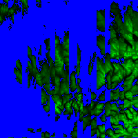
The original height database in version 1
(heights2_orig.bin.gz) had corruption in
the "NG" grid square, as can be seen from a plot of the original NG square data
(the corruption was fixed earlier by G3NKL and the height database in version 2 is OK):
The original height database can be identified as having an MD5 message
digest of 8fc0a92b69ea5dcbfe3179111689abfe.
The main corruption is the stripe effect on the data, which was
removed moderately easily, as can be seen from a plot of the de-striped
NG square data:

However this leaves some problems at the bottom of the square (i.e.
the row of pixels above this text). There are extraneous pixels at
the left hand side of the image, there are missing pixels in the
island to the left of the centre line (this island is Rhum), and
there are missing pixels in the land mass on the right hand side (this
is the Knoydart peninsular).
If you want the version of the height database with just these
fixes in, it's heights2_destriped.bin.gz
with an MD5 message digest of 3bbd15999bb49b1d8fe610fc3438f900.
These errors had to be fixed manually, involving maps and magnifying
glasses. The result can be seen on the plot of the final NG square data:
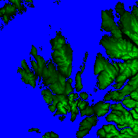
My final version of the height database is heights2_final.bin.gz. It has a MD5 message digest of 87d53e53a0f97a24da431dfffe799315.
Of course, if you're using version 2 of the software, the height database is already fixed. The database in version 2 differs slightly from my final database, in terms of the heights for grid references NG305000-NG335000, NG400000-NG420000, NG720000-NG735000, NG800000-NG835000, NG900000-NG935000, NH000095, and NH035095-NH040095. Its MD5 message digest is c2e6fe76cfde0260da8597c4e3fe5df8. I need to double check the two versions of the database to see which set of disputed heights is more accurate.